
Fichièr:Map German World.png

Talha d'aquesta previsualizacion: 800 × 372 pixèls. Autras resolucions : 320 × 149 pixèls | 640 × 297 pixèls | 1 337 × 621 pixèls.
Fichièr d'origina (1 337 × 621 pixèl, talha del fichièr: 240 Ko, tipe MIME: image/png)

|
Una version vectoriala d'aqueste imatge existís, dins lo format "SVG".
Deuriá èsser utilizada a la plaça de la presenta version per d'afichatges en dimensions mai grandas o que necessitan una resolucion melhora. File:Map German World.png → File:Legal statuses of German in the world.svg
Per mai d'entresenhas suls imatges vectorials, consultatz la pagina de transicion de Commons cap al format SVG. Vejatz tanben las entresenhas a prepaus del biais que lo logicial MediaWiki supòrta los imatges al format SVG. |
 |
| Descripcion |
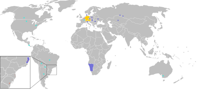
Čeština: Legenda:
původní jazyk
druhý nebo neoficiální jazyk
německá menšina Deutsch: Legende:
Amtssprache/Muttersprache
Zweitsprache, „Nationalsprache“ oder nicht offizielle Amtssprache.
Deutsche Minderheiten English: Legend:
native language
Secondary language "national language" or non-official.
German minorities Suomi: Värien merkitys:
äidinkieli
toinen tai ei-virallinen kieli
saksankielisiä vähemmistöjä Français : Carte du monde où on parle l'allemand.
langue maternelle
langue importante, "langue nationale" et/ou langue de culture
minorités allemandes עברית:
Italiano: Legenda:
lingua materna
seconda lingua o lingua non ufficiale
minoranze tedesche Lëtzebuergesch: Legend:
Amtssprooch/Mammesprooch
Zweetsprooch, „Nationalsprooch“ oder net offiziell Amtssprooch
Däitsch Mannerheeten Polski: Legenda:
Język urzędowy/Język ojczysty
Drugi język ojczysty albo nieoficjalny język urzędowy.
Mniejszości Niemieckie Português: Legenda:
língua mãe
língua importante, "língua nacional" e/ou língua de cultura
minorias alemãs Română: Legendă:
limbă maternă naţională
limbă secundară, „limbă națională” sau neoficială
minorități germane Русский: Легенда:
Государственный/Родной язык.
Второй или неофициальный государственный язык.
Немецкие национальные меньшинства Українська: Легенда:
Рідна мова.
Другорядна "національна мова" або неофіційна.
Німецькі меншини |
||
| Font | Image:BlankMap-World.png | ||
| Autor | User:Ilario | ||
| Permission (Reütilizacion d'aqueste fichièr) |
|
||
| Autras versions | File is obsolete! Use File:Legal statuses of German in the world.svg instead. |
Istoric del fichièr
Clicar sus una data e una ora per veire lo fichièr tal coma èra a aqueste moment
| Data e ora | Miniatura | Dimensions | Utilizaire | Comentari | |
|---|---|---|---|---|---|
| actual | 19 setembre de 2016 a 21.59 | | 1 337 × 621 (240 Ko) | Alatab | I added a square in northern Costa Rica, because there is one of the most important and biggest German speakers communities in Central America and the Caribbean. Also the German is one of the most used foreign languages in the country. |
| 15 setembre de 2014 a 01.08 |  | 1 357 × 628 (35 Ko) | Leftcry | Border fix | |
| 17 febrièr de 2009 a 00.44 |  | 1 357 × 628 (24 Ko) | Disposable.Heroes | pngcrush | |
| 30 setembre de 2006 a 13.17 |  | 1 357 × 628 (53 Ko) | Huhsunqu | Pozuzo | |
| 26 junh de 2006 a 14.24 |  | 1 357 × 628 (53 Ko) | Roke~commonswiki | talk page comment to include Alemán Coloniero in venezuela | |
| 18 genièr de 2006 a 11.29 |  | 1 357 × 628 (30 Ko) | Ilario | Map made from Image:BlankMap-World.png {{PD-user|Yug}} {{en|Legend: *Dark Orange: native language *Light orange: Secondary language or non-official. *Orange square: German minorities}} {{fr|Carte du monde où on parle l'italien. *Orange foncé: lan |
Paginas que contenon lo fichièr
I a ges de pagina que compòrta un ligam vèrs aqueste imatge.
Usatge global del fichièr
Los autres wikis seguents utilizan aqueste imatge :
- Utilizacion sus cy.wikipedia.org
- Utilizacion sus en.wikipedia.org
- Utilizacion sus fr.wikipedia.org
- Utilizacion sus it.wikipedia.org